|
|
|||||||||||||||||
| Point ID: 7046 | Downloads | Plots | Site Data | Code: 11389 |
|
|
|||||||||||||||||
| Download | |
|---|---|
| Site Descriptor Information | Site Time Series Data |
| Link to all available data | |
| View: | Time Series | All |
| Units: | mm |
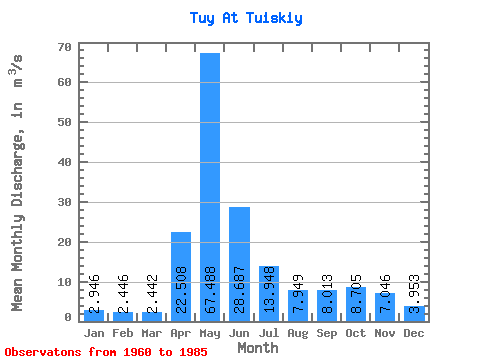
| Statistic | Jan | Feb | Mar | Apr | May | Jun | Jul | Aug | Sep | Oct | Nov | Dec | Annual |
|---|---|---|---|---|---|---|---|---|---|---|---|---|---|
| Mean | 2.95 | 2.45 | 2.44 | 22.51 | 67.49 | 28.69 | 13.95 | 7.95 | 8.01 | 8.71 | 7.05 | 3.95 | 14.60 |
| Standard Deviation | 1.15 | 0.98 | 0.63 | 16.93 | 25.97 | 25.50 | 16.57 | 5.87 | 4.43 | 5.59 | 4.35 | 1.52 | 5.70 |
| Min | 0.76 | 0.24 | 1.18 | 2.24 | 8.39 | 5.16 | 2.57 | 1.98 | 1.95 | 2.04 | 2.23 | 1.38 | 4.19 |
| Max | 6.29 | 4.81 | 3.46 | 61.20 | 110.00 | 122.00 | 81.60 | 24.70 | 17.40 | 29.70 | 20.30 | 7.88 | 28.77 |
| Coefficient of Variation | 0.39 | 0.40 | 0.26 | 0.75 | 0.39 | 0.89 | 1.19 | 0.74 | 0.55 | 0.64 | 0.62 | 0.38 | 0.39 |
 Return to R-Arctic Net Home Page