|
|
|||||||||||||||||
| Point ID: 7046 | Downloads | Plots | Site Data | Code: 11389 |
|
|
|||||||||||||||||
| Download | |
|---|---|
| Site Descriptor Information | Site Time Series Data |
| Link to all available data | |
| View: | Time Series | All |
| Units: | m3/s |
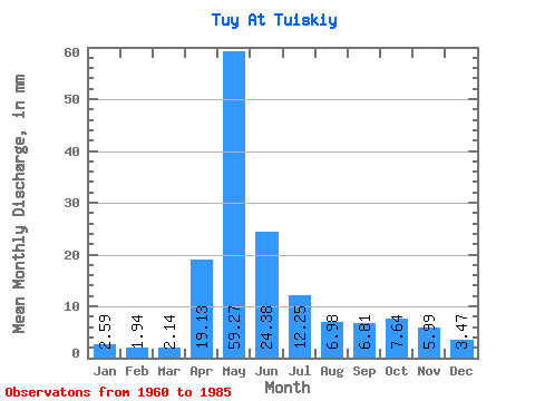
| Statistic | Jan | Feb | Mar | Apr | May | Jun | Jul | Aug | Sep | Oct | Nov | Dec | Annual |
|---|---|---|---|---|---|---|---|---|---|---|---|---|---|
| Mean | 2.59 | 1.96 | 2.14 | 19.13 | 59.26 | 24.38 | 12.25 | 6.98 | 6.81 | 7.64 | 5.99 | 3.47 | 151.08 |
| Standard Deviation | 1.01 | 0.78 | 0.56 | 14.39 | 22.80 | 21.67 | 14.55 | 5.15 | 3.76 | 4.91 | 3.70 | 1.33 | 58.94 |
| Min | 0.67 | 0.20 | 1.04 | 1.90 | 7.37 | 4.38 | 2.26 | 1.74 | 1.66 | 1.79 | 1.90 | 1.21 | 43.34 |
| Max | 5.52 | 3.85 | 3.04 | 52.01 | 96.58 | 103.68 | 71.65 | 21.69 | 14.79 | 26.08 | 17.25 | 6.92 | 297.69 |
| Coefficient of Variation | 0.39 | 0.40 | 0.26 | 0.75 | 0.39 | 0.89 | 1.19 | 0.74 | 0.55 | 0.64 | 0.62 | 0.38 | 0.39 |
 Return to R-Arctic Net Home Page