|
|
|||||||||||||||||
| Point ID: 7042 | Downloads | Plots | Site Data | Code: 11383 |
|
|
|||||||||||||||||
| Download | |
|---|---|
| Site Descriptor Information | Site Time Series Data |
| Link to all available data | |
| View: | Time Series | All |
| Units: | mm |
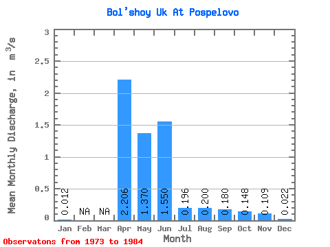
| Statistic | Jan | Feb | Mar | Apr | May | Jun | Jul | Aug | Sep | Oct | Nov | Dec | Annual |
|---|---|---|---|---|---|---|---|---|---|---|---|---|---|
| Mean | 0.01 | 2.21 | 1.37 | 1.55 | 0.20 | 0.20 | 0.18 | 0.15 | 0.11 | 0.02 | |||
| Standard Deviation | 0.00 | 1.41 | 1.15 | 3.02 | 0.26 | 0.25 | 0.24 | 0.19 | 0.09 | 0.01 | |||
| Min | 0.01 | 0.12 | 0.02 | 0.03 | 0.01 | 0.02 | 0.01 | 0.00 | 0.02 | 0.01 | |||
| Max | 0.01 | 4.03 | 3.00 | 8.90 | 0.57 | 0.49 | 0.35 | 0.41 | 0.24 | 0.03 | |||
| Coefficient of Variation | 0.06 | 0.64 | 0.84 | 1.95 | 1.32 | 1.27 | 1.34 | 1.29 | 0.87 | 0.63 |
 Return to R-Arctic Net Home Page