|
|
|||||||||||||||||
| Point ID: 7042 | Downloads | Plots | Site Data | Code: 11383 |
|
|
|||||||||||||||||
| Download | |
|---|---|
| Site Descriptor Information | Site Time Series Data |
| Link to all available data | |
| View: | Time Series | All |
| Units: | m3/s |
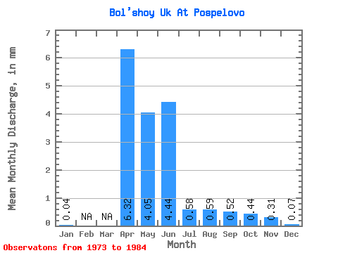
| Statistic | Jan | Feb | Mar | Apr | May | Jun | Jul | Aug | Sep | Oct | Nov | Dec | Annual |
|---|---|---|---|---|---|---|---|---|---|---|---|---|---|
| Mean | 0.03 | 6.32 | 4.05 | 4.44 | 0.58 | 0.59 | 0.52 | 0.44 | 0.31 | 0.06 | |||
| Standard Deviation | 0.00 | 4.04 | 3.41 | 8.66 | 0.77 | 0.75 | 0.69 | 0.57 | 0.27 | 0.04 | |||
| Min | 0.03 | 0.34 | 0.07 | 0.10 | 0.02 | 0.05 | 0.03 | 0.01 | 0.05 | 0.02 | |||
| Max | 0.04 | 11.54 | 8.88 | 25.49 | 1.69 | 1.45 | 1.00 | 1.21 | 0.69 | 0.10 | |||
| Coefficient of Variation | 0.06 | 0.64 | 0.84 | 1.95 | 1.32 | 1.27 | 1.34 | 1.29 | 0.87 | 0.63 |
 Return to R-Arctic Net Home Page