|
|
|||||||||||||||||
| Point ID: 7038 | Downloads | Plots | Site Data | Code: 11372 |
|
|
|||||||||||||||||
| Download | |
|---|---|
| Site Descriptor Information | Site Time Series Data |
| Link to all available data | |
| View: | Time Series | All |
| Units: | mm |
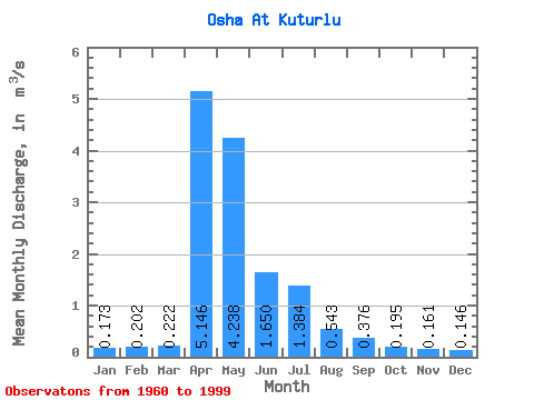
| Statistic | Jan | Feb | Mar | Apr | May | Jun | Jul | Aug | Sep | Oct | Nov | Dec | Annual |
|---|---|---|---|---|---|---|---|---|---|---|---|---|---|
| Mean | 0.17 | 0.20 | 0.22 | 5.15 | 4.24 | 1.65 | 1.38 | 0.54 | 0.38 | 0.20 | 0.16 | 0.15 | 1.28 |
| Standard Deviation | 0.42 | 0.45 | 0.48 | 3.87 | 4.44 | 1.85 | 1.83 | 0.70 | 0.60 | 0.63 | 0.48 | 0.41 | 1.21 |
| Min | 0.00 | 0.00 | 0.00 | 0.38 | 0.08 | 0.01 | 0.00 | 0.00 | 0.00 | 0.00 | 0.00 | 0.00 | 0.06 |
| Max | 1.61 | 1.70 | 2.10 | 17.30 | 19.50 | 7.99 | 5.85 | 2.21 | 2.43 | 3.20 | 2.34 | 1.94 | 4.06 |
| Coefficient of Variation | 2.41 | 2.21 | 2.14 | 0.75 | 1.05 | 1.12 | 1.32 | 1.29 | 1.61 | 3.22 | 2.99 | 2.83 | 0.94 |
 Return to R-Arctic Net Home Page