|
|
|||||||||||||||||
| Point ID: 7038 | Downloads | Plots | Site Data | Code: 11372 |
|
|
|||||||||||||||||
| Download | |
|---|---|
| Site Descriptor Information | Site Time Series Data |
| Link to all available data | |
| View: | Time Series | All |
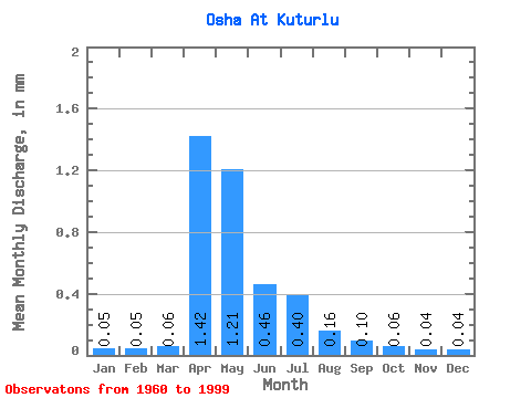
| Units: | m3/s |
| Statistic | Jan | Feb | Mar | Apr | May | Jun | Jul | Aug | Sep | Oct | Nov | Dec | Annual |
|---|---|---|---|---|---|---|---|---|---|---|---|---|---|
| Mean | 0.05 | 0.05 | 0.06 | 1.42 | 1.21 | 0.46 | 0.40 | 0.15 | 0.10 | 0.06 | 0.04 | 0.04 | 4.32 |
| Standard Deviation | 0.12 | 0.12 | 0.14 | 1.07 | 1.27 | 0.51 | 0.52 | 0.20 | 0.17 | 0.18 | 0.13 | 0.12 | 4.08 |
| Min | 0.00 | 0.00 | 0.00 | 0.10 | 0.02 | 0.00 | 0.00 | 0.00 | 0.00 | 0.00 | 0.00 | 0.00 | 0.20 |
| Max | 0.46 | 0.44 | 0.60 | 4.78 | 5.57 | 2.21 | 1.67 | 0.63 | 0.67 | 0.91 | 0.65 | 0.55 | 13.65 |
| Coefficient of Variation | 2.41 | 2.21 | 2.14 | 0.75 | 1.05 | 1.12 | 1.32 | 1.29 | 1.61 | 3.22 | 2.99 | 2.83 | 0.94 |
 Return to R-Arctic Net Home Page