|
|
|||||||||||||||||
| Point ID: 7036 | Downloads | Plots | Site Data | Code: 11369 |
|
|
|||||||||||||||||
| Download | |
|---|---|
| Site Descriptor Information | Site Time Series Data |
| Link to all available data | |
| View: | Time Series | All |
| Units: | mm |
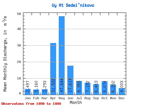
| Statistic | Jan | Feb | Mar | Apr | May | Jun | Jul | Aug | Sep | Oct | Nov | Dec | Annual |
|---|---|---|---|---|---|---|---|---|---|---|---|---|---|
| Mean | 3.50 | 3.16 | 3.29 | 31.53 | 47.84 | 17.62 | 8.35 | 7.19 | 6.41 | 8.07 | 6.20 | 4.00 | 12.31 |
| Standard Deviation | 0.92 | 0.76 | 0.72 | 17.96 | 27.91 | 12.05 | 6.27 | 5.21 | 3.81 | 5.17 | 3.73 | 1.23 | 4.94 |
| Min | 1.64 | 1.84 | 1.76 | 5.24 | 5.17 | 3.23 | 2.46 | 2.84 | 1.84 | 2.53 | 2.27 | 1.95 | 3.32 |
| Max | 5.50 | 5.18 | 5.25 | 78.40 | 106.00 | 61.60 | 35.50 | 28.60 | 17.90 | 24.90 | 22.60 | 7.33 | 25.18 |
| Coefficient of Variation | 0.26 | 0.24 | 0.22 | 0.57 | 0.58 | 0.68 | 0.75 | 0.72 | 0.59 | 0.64 | 0.60 | 0.31 | 0.40 |
 Return to R-Arctic Net Home Page