|
|
|||||||||||||||||
| Point ID: 7036 | Downloads | Plots | Site Data | Code: 11369 |
|
|
|||||||||||||||||
| Download | |
|---|---|
| Site Descriptor Information | Site Time Series Data |
| Link to all available data | |
| View: | Time Series | All |
| Units: | m3/s |
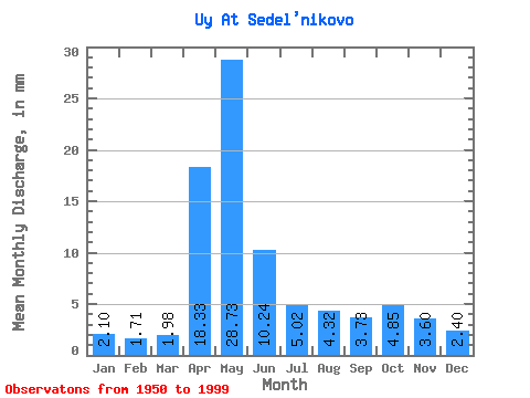
| Statistic | Jan | Feb | Mar | Apr | May | Jun | Jul | Aug | Sep | Oct | Nov | Dec | Annual |
|---|---|---|---|---|---|---|---|---|---|---|---|---|---|
| Mean | 2.10 | 1.73 | 1.98 | 18.32 | 28.73 | 10.24 | 5.02 | 4.32 | 3.73 | 4.85 | 3.60 | 2.40 | 87.10 |
| Standard Deviation | 0.56 | 0.42 | 0.43 | 10.44 | 16.76 | 7.00 | 3.77 | 3.13 | 2.21 | 3.10 | 2.17 | 0.74 | 34.95 |
| Min | 0.98 | 1.01 | 1.06 | 3.04 | 3.10 | 1.88 | 1.48 | 1.71 | 1.07 | 1.52 | 1.32 | 1.17 | 23.47 |
| Max | 3.30 | 2.83 | 3.15 | 45.56 | 63.65 | 35.80 | 21.32 | 17.17 | 10.40 | 14.95 | 13.13 | 4.40 | 178.18 |
| Coefficient of Variation | 0.26 | 0.24 | 0.22 | 0.57 | 0.58 | 0.68 | 0.75 | 0.72 | 0.59 | 0.64 | 0.60 | 0.31 | 0.40 |
 Return to R-Arctic Net Home Page