|
|
|||||||||||||||||
| Point ID: 7034 | Downloads | Plots | Site Data | Code: 11362 |
|
|
|||||||||||||||||
| Download | |
|---|---|
| Site Descriptor Information | Site Time Series Data |
| Link to all available data | |
| View: | Time Series | All |
| Units: | mm |
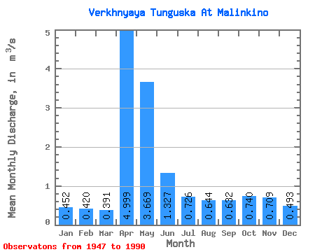
| Statistic | Jan | Feb | Mar | Apr | May | Jun | Jul | Aug | Sep | Oct | Nov | Dec | Annual |
|---|---|---|---|---|---|---|---|---|---|---|---|---|---|
| Mean | 0.45 | 0.42 | 0.39 | 5.00 | 3.67 | 1.33 | 0.73 | 0.64 | 0.63 | 0.74 | 0.71 | 0.49 | 1.19 |
| Standard Deviation | 0.29 | 0.23 | 0.20 | 3.38 | 2.53 | 0.82 | 0.46 | 0.45 | 0.41 | 0.51 | 0.58 | 0.27 | 0.54 |
| Min | 0.10 | 0.07 | 0.13 | 0.84 | 0.43 | 0.35 | 0.29 | 0.23 | 0.26 | 0.24 | 0.20 | 0.17 | 0.38 |
| Max | 1.69 | 1.27 | 0.96 | 15.50 | 11.80 | 3.93 | 2.27 | 2.93 | 2.55 | 2.48 | 2.64 | 1.66 | 2.79 |
| Coefficient of Variation | 0.64 | 0.55 | 0.51 | 0.68 | 0.69 | 0.62 | 0.64 | 0.70 | 0.66 | 0.69 | 0.82 | 0.55 | 0.45 |
 Return to R-Arctic Net Home Page