|
|
|||||||||||||||||
| Point ID: 7034 | Downloads | Plots | Site Data | Code: 11362 |
|
|
|||||||||||||||||
| Download | |
|---|---|
| Site Descriptor Information | Site Time Series Data |
| Link to all available data | |
| View: | Time Series | All |
| Units: | m3/s |
| Statistic | Jan | Feb | Mar | Apr | May | Jun | Jul | Aug | Sep | Oct | Nov | Dec | Annual |
|---|---|---|---|---|---|---|---|---|---|---|---|---|---|
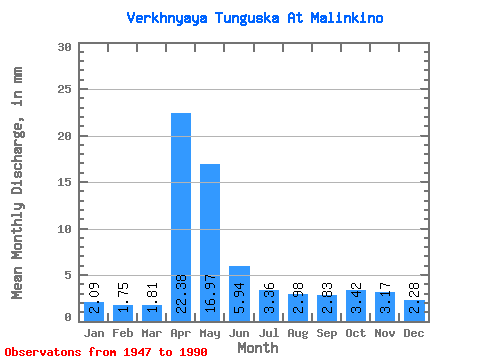
| Mean | 2.09 | 1.77 | 1.81 | 22.38 | 16.97 | 5.94 | 3.36 | 2.98 | 2.83 | 3.42 | 3.18 | 2.28 | 65.04 |
| Standard Deviation | 1.34 | 0.97 | 0.93 | 15.11 | 11.71 | 3.69 | 2.13 | 2.08 | 1.86 | 2.38 | 2.61 | 1.25 | 29.48 |
| Min | 0.46 | 0.28 | 0.60 | 3.76 | 1.99 | 1.57 | 1.34 | 1.06 | 1.16 | 1.11 | 0.90 | 0.79 | 20.88 |
| Max | 7.82 | 5.35 | 4.44 | 69.39 | 54.58 | 17.59 | 10.50 | 13.55 | 11.42 | 11.47 | 11.82 | 7.68 | 151.99 |
| Coefficient of Variation | 0.64 | 0.55 | 0.51 | 0.68 | 0.69 | 0.62 | 0.64 | 0.70 | 0.66 | 0.69 | 0.82 | 0.55 | 0.45 |
 Return to R-Arctic Net Home Page