|
|
|||||||||||||||||
| Point ID: 7028 | Downloads | Plots | Site Data | Code: 11351 |
|
|
|||||||||||||||||
| Download | |
|---|---|
| Site Descriptor Information | Site Time Series Data |
| Link to all available data | |
| View: | Time Series | All |
| Units: | mm |
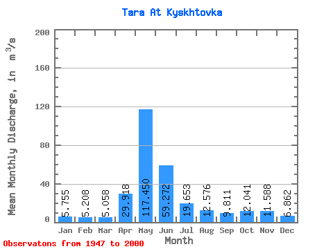
| Statistic | Jan | Feb | Mar | Apr | May | Jun | Jul | Aug | Sep | Oct | Nov | Dec | Annual |
|---|---|---|---|---|---|---|---|---|---|---|---|---|---|
| Mean | 5.75 | 5.21 | 5.06 | 29.92 | 117.45 | 59.27 | 19.65 | 12.58 | 9.81 | 12.04 | 11.59 | 6.86 | 24.61 |
| Standard Deviation | 1.93 | 1.11 | 0.81 | 17.05 | 68.60 | 49.51 | 17.40 | 11.48 | 8.04 | 9.19 | 7.69 | 3.46 | 13.05 |
| Min | 4.05 | 4.01 | 3.98 | 6.82 | 16.60 | 7.44 | 3.55 | 4.71 | 4.66 | 4.82 | 4.27 | 4.15 | 7.24 |
| Max | 12.50 | 7.87 | 7.36 | 69.00 | 258.00 | 211.00 | 79.30 | 61.70 | 44.70 | 35.40 | 29.30 | 20.50 | 64.32 |
| Coefficient of Variation | 0.34 | 0.21 | 0.16 | 0.57 | 0.58 | 0.83 | 0.89 | 0.91 | 0.82 | 0.76 | 0.66 | 0.50 | 0.53 |
 Return to R-Arctic Net Home Page