|
|
|||||||||||||||||
| Point ID: 7028 | Downloads | Plots | Site Data | Code: 11351 |
|
|
|||||||||||||||||
| Download | |
|---|---|
| Site Descriptor Information | Site Time Series Data |
| Link to all available data | |
| View: | Time Series | All |
| Units: | m3/s |
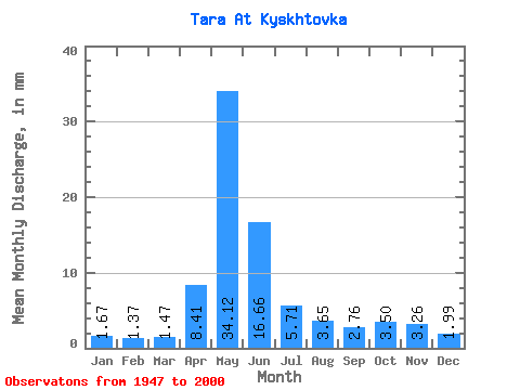
| Statistic | Jan | Feb | Mar | Apr | May | Jun | Jul | Aug | Sep | Oct | Nov | Dec | Annual |
|---|---|---|---|---|---|---|---|---|---|---|---|---|---|
| Mean | 1.67 | 1.38 | 1.47 | 8.41 | 34.11 | 16.66 | 5.71 | 3.65 | 2.76 | 3.50 | 3.26 | 1.99 | 84.23 |
| Standard Deviation | 0.56 | 0.29 | 0.23 | 4.79 | 19.92 | 13.92 | 5.05 | 3.33 | 2.26 | 2.67 | 2.16 | 1.00 | 44.66 |
| Min | 1.18 | 1.06 | 1.16 | 1.92 | 4.82 | 2.09 | 1.03 | 1.37 | 1.31 | 1.40 | 1.20 | 1.21 | 24.79 |
| Max | 3.63 | 2.08 | 2.14 | 19.40 | 74.94 | 59.32 | 23.03 | 17.92 | 12.57 | 10.28 | 8.24 | 5.95 | 220.16 |
| Coefficient of Variation | 0.34 | 0.21 | 0.16 | 0.57 | 0.58 | 0.83 | 0.89 | 0.91 | 0.82 | 0.76 | 0.66 | 0.50 | 0.53 |
 Return to R-Arctic Net Home Page