|
|
|||||||||||||||||
| Point ID: 7026 | Downloads | Plots | Site Data | Code: 11348 |
|
|
|||||||||||||||||
| Download | |
|---|---|
| Site Descriptor Information | Site Time Series Data |
| Link to all available data | |
| View: | Time Series | All |
| Units: | mm |
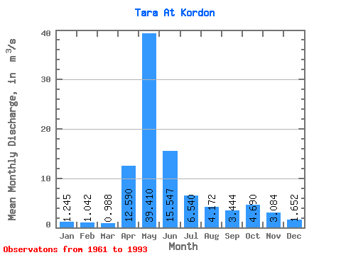
| Statistic | Jan | Feb | Mar | Apr | May | Jun | Jul | Aug | Sep | Oct | Nov | Dec | Annual |
|---|---|---|---|---|---|---|---|---|---|---|---|---|---|
| Mean | 1.25 | 1.04 | 0.99 | 12.59 | 39.41 | 15.55 | 6.54 | 4.17 | 3.44 | 4.69 | 3.08 | 1.65 | 7.80 |
| Standard Deviation | 0.86 | 0.57 | 0.35 | 13.01 | 31.24 | 15.04 | 8.61 | 4.31 | 3.01 | 4.75 | 2.81 | 1.39 | 5.35 |
| Min | 0.37 | 0.32 | 0.24 | 0.96 | 1.51 | 0.77 | 0.76 | 0.87 | 0.83 | 0.73 | 0.40 | 0.44 | 0.74 |
| Max | 4.38 | 2.89 | 1.91 | 50.30 | 110.00 | 67.00 | 44.60 | 18.40 | 13.60 | 18.10 | 12.40 | 7.63 | 22.97 |
| Coefficient of Variation | 0.69 | 0.55 | 0.35 | 1.03 | 0.79 | 0.97 | 1.32 | 1.03 | 0.88 | 1.01 | 0.91 | 0.84 | 0.69 |
 Return to R-Arctic Net Home Page