|
|
|||||||||||||||||
| Point ID: 7026 | Downloads | Plots | Site Data | Code: 11348 |
|
|
|||||||||||||||||
| Download | |
|---|---|
| Site Descriptor Information | Site Time Series Data |
| Link to all available data | |
| View: | Time Series | All |
| Units: | m3/s |
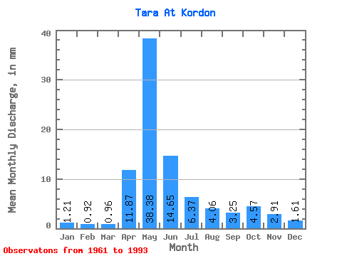
| Statistic | Jan | Feb | Mar | Apr | May | Jun | Jul | Aug | Sep | Oct | Nov | Dec | Annual |
|---|---|---|---|---|---|---|---|---|---|---|---|---|---|
| Mean | 1.21 | 0.92 | 0.96 | 11.87 | 38.38 | 14.65 | 6.37 | 4.06 | 3.25 | 4.57 | 2.91 | 1.61 | 89.54 |
| Standard Deviation | 0.83 | 0.51 | 0.34 | 12.27 | 30.42 | 14.18 | 8.39 | 4.20 | 2.84 | 4.63 | 2.65 | 1.35 | 61.41 |
| Min | 0.36 | 0.28 | 0.23 | 0.91 | 1.47 | 0.73 | 0.74 | 0.85 | 0.78 | 0.71 | 0.38 | 0.43 | 8.51 |
| Max | 4.26 | 2.56 | 1.86 | 47.41 | 107.12 | 63.15 | 43.43 | 17.92 | 12.82 | 17.63 | 11.69 | 7.43 | 263.57 |
| Coefficient of Variation | 0.69 | 0.55 | 0.35 | 1.03 | 0.79 | 0.97 | 1.32 | 1.03 | 0.88 | 1.01 | 0.91 | 0.84 | 0.69 |
 Return to R-Arctic Net Home Page