|
|
|||||||||||||||||
| Point ID: 7020 | Downloads | Plots | Site Data | Code: 11335 |
|
|
|||||||||||||||||
| Download | |
|---|---|
| Site Descriptor Information | Site Time Series Data |
| Link to all available data | |
| View: | Time Series | All |
| Units: | mm |
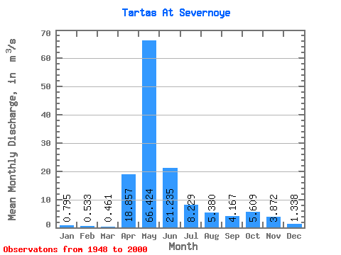
| Statistic | Jan | Feb | Mar | Apr | May | Jun | Jul | Aug | Sep | Oct | Nov | Dec | Annual |
|---|---|---|---|---|---|---|---|---|---|---|---|---|---|
| Mean | 0.80 | 0.53 | 0.46 | 18.86 | 66.42 | 21.23 | 8.23 | 5.38 | 4.17 | 5.61 | 3.87 | 1.34 | 11.41 |
| Standard Deviation | 0.90 | 0.42 | 0.25 | 21.87 | 51.65 | 22.43 | 12.09 | 10.55 | 7.23 | 7.45 | 4.70 | 1.76 | 8.96 |
| Min | 0.21 | 0.16 | 0.17 | 0.73 | 2.20 | 0.73 | 0.31 | 0.29 | 0.29 | 0.34 | 0.28 | 0.26 | 0.79 |
| Max | 4.91 | 2.83 | 1.70 | 90.90 | 199.00 | 98.20 | 69.30 | 67.60 | 45.10 | 27.90 | 18.10 | 8.61 | 40.76 |
| Coefficient of Variation | 1.14 | 0.79 | 0.54 | 1.16 | 0.78 | 1.06 | 1.47 | 1.96 | 1.73 | 1.33 | 1.21 | 1.31 | 0.79 |
 Return to R-Arctic Net Home Page