|
|
|||||||||||||||||
| Point ID: 7020 | Downloads | Plots | Site Data | Code: 11335 |
|
|
|||||||||||||||||
| Download | |
|---|---|
| Site Descriptor Information | Site Time Series Data |
| Link to all available data | |
| View: | Time Series | All |
| Units: | m3/s |
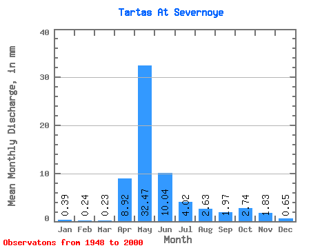
| Statistic | Jan | Feb | Mar | Apr | May | Jun | Jul | Aug | Sep | Oct | Nov | Dec | Annual |
|---|---|---|---|---|---|---|---|---|---|---|---|---|---|
| Mean | 0.39 | 0.24 | 0.23 | 8.92 | 32.46 | 10.04 | 4.02 | 2.63 | 1.97 | 2.74 | 1.83 | 0.65 | 65.70 |
| Standard Deviation | 0.44 | 0.19 | 0.12 | 10.34 | 25.24 | 10.61 | 5.91 | 5.16 | 3.42 | 3.64 | 2.22 | 0.86 | 51.61 |
| Min | 0.10 | 0.07 | 0.08 | 0.34 | 1.07 | 0.34 | 0.15 | 0.14 | 0.14 | 0.17 | 0.13 | 0.13 | 4.55 |
| Max | 2.40 | 1.26 | 0.83 | 42.99 | 97.25 | 46.45 | 33.87 | 33.03 | 21.33 | 13.63 | 8.56 | 4.21 | 234.71 |
| Coefficient of Variation | 1.14 | 0.79 | 0.54 | 1.16 | 0.78 | 1.06 | 1.47 | 1.96 | 1.73 | 1.33 | 1.21 | 1.31 | 0.79 |
 Return to R-Arctic Net Home Page