|
|
|||||||||||||||||
| Point ID: 7019 | Downloads | Plots | Site Data | Code: 11334 |
|
|
|||||||||||||||||
| Download | |
|---|---|
| Site Descriptor Information | Site Time Series Data |
| Link to all available data | |
| View: | Time Series | All |
| Units: | mm |
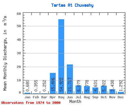
| Statistic | Jan | Feb | Mar | Apr | May | Jun | Jul | Aug | Sep | Oct | Nov | Dec | Annual |
|---|---|---|---|---|---|---|---|---|---|---|---|---|---|
| Mean | 0.68 | 0.35 | 0.25 | 15.41 | 54.92 | 21.72 | 6.08 | 5.78 | 4.63 | 5.92 | 3.44 | 1.29 | 10.07 |
| Standard Deviation | 1.00 | 0.51 | 0.29 | 15.73 | 45.26 | 21.45 | 7.19 | 14.21 | 8.95 | 8.27 | 4.33 | 2.16 | 7.88 |
| Min | 0.01 | 0.01 | 0.01 | 0.36 | 0.18 | 0.67 | 0.12 | 0.07 | 0.06 | 0.09 | 0.11 | 0.08 | 1.23 |
| Max | 4.18 | 2.23 | 1.24 | 58.00 | 126.00 | 87.50 | 28.20 | 66.30 | 40.30 | 25.60 | 14.70 | 7.69 | 26.26 |
| Coefficient of Variation | 1.47 | 1.44 | 1.14 | 1.02 | 0.82 | 0.99 | 1.18 | 2.46 | 1.93 | 1.40 | 1.26 | 1.67 | 0.78 |
 Return to R-Arctic Net Home Page