|
|
|||||||||||||||||
| Point ID: 7019 | Downloads | Plots | Site Data | Code: 11334 |
|
|
|||||||||||||||||
| Download | |
|---|---|
| Site Descriptor Information | Site Time Series Data |
| Link to all available data | |
| View: | Time Series | All |
| Units: | m3/s |
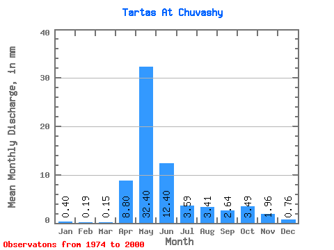
| Statistic | Jan | Feb | Mar | Apr | May | Jun | Jul | Aug | Sep | Oct | Nov | Dec | Annual |
|---|---|---|---|---|---|---|---|---|---|---|---|---|---|
| Mean | 0.40 | 0.19 | 0.15 | 8.80 | 32.40 | 12.40 | 3.59 | 3.41 | 2.64 | 3.49 | 1.96 | 0.76 | 70.01 |
| Standard Deviation | 0.59 | 0.27 | 0.17 | 8.98 | 26.70 | 12.24 | 4.24 | 8.38 | 5.11 | 4.88 | 2.47 | 1.27 | 54.74 |
| Min | 0.00 | 0.00 | 0.00 | 0.21 | 0.11 | 0.38 | 0.07 | 0.04 | 0.03 | 0.05 | 0.06 | 0.04 | 8.52 |
| Max | 2.47 | 1.20 | 0.73 | 33.11 | 74.32 | 49.96 | 16.63 | 39.11 | 23.01 | 15.10 | 8.39 | 4.54 | 182.57 |
| Coefficient of Variation | 1.47 | 1.44 | 1.14 | 1.02 | 0.82 | 0.99 | 1.18 | 2.46 | 1.93 | 1.40 | 1.26 | 1.67 | 0.78 |
 Return to R-Arctic Net Home Page