|
|
|||||||||||||||||
| Point ID: 7017 | Downloads | Plots | Site Data | Code: 11330 |
|
|
|||||||||||||||||
| Download | |
|---|---|
| Site Descriptor Information | Site Time Series Data |
| Link to all available data | |
| View: | Time Series | All |
| Units: | mm |
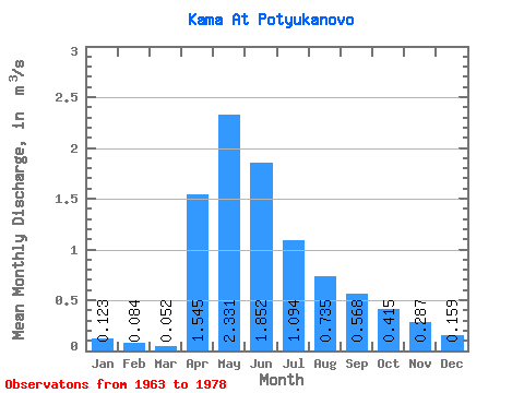
| Statistic | Jan | Feb | Mar | Apr | May | Jun | Jul | Aug | Sep | Oct | Nov | Dec | Annual |
|---|---|---|---|---|---|---|---|---|---|---|---|---|---|
| Mean | 0.12 | 0.08 | 0.05 | 1.54 | 2.33 | 1.85 | 1.09 | 0.73 | 0.57 | 0.41 | 0.29 | 0.16 | 1.08 |
| Standard Deviation | 0.10 | 0.06 | 0.05 | 1.45 | 2.71 | 2.09 | 1.24 | 0.68 | 0.41 | 0.30 | 0.25 | 0.18 | 0.80 |
| Min | 0.01 | 0.01 | 0.01 | 0.12 | 0.06 | 0.10 | 0.09 | 0.13 | 0.11 | 0.07 | 0.07 | 0.00 | 0.24 |
| Max | 0.30 | 0.19 | 0.12 | 5.18 | 8.54 | 5.85 | 3.91 | 2.37 | 1.30 | 0.90 | 0.71 | 0.55 | 2.36 |
| Coefficient of Variation | 0.81 | 0.73 | 0.88 | 0.94 | 1.16 | 1.13 | 1.13 | 0.93 | 0.73 | 0.73 | 0.86 | 1.12 | 0.74 |
 Return to R-Arctic Net Home Page