|
|
|||||||||||||||||
| Point ID: 7017 | Downloads | Plots | Site Data | Code: 11330 |
|
|
|||||||||||||||||
| Download | |
|---|---|
| Site Descriptor Information | Site Time Series Data |
| Link to all available data | |
| View: | Time Series | All |
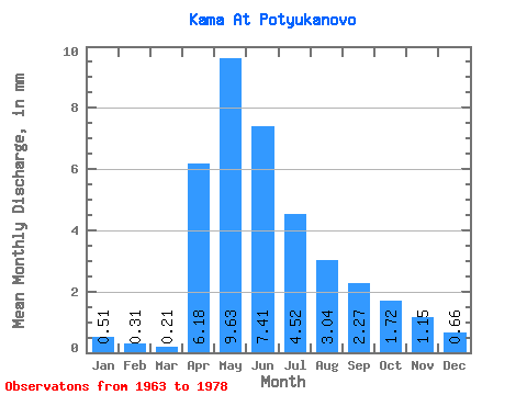
| Units: | m3/s |
| Statistic | Jan | Feb | Mar | Apr | May | Jun | Jul | Aug | Sep | Oct | Nov | Dec | Annual |
|---|---|---|---|---|---|---|---|---|---|---|---|---|---|
| Mean | 0.51 | 0.32 | 0.21 | 6.18 | 9.63 | 7.41 | 4.52 | 3.04 | 2.27 | 1.72 | 1.15 | 0.66 | 52.43 |
| Standard Deviation | 0.41 | 0.23 | 0.19 | 5.81 | 11.18 | 8.36 | 5.12 | 2.83 | 1.66 | 1.26 | 0.99 | 0.74 | 38.96 |
| Min | 0.03 | 0.06 | 0.03 | 0.48 | 0.24 | 0.40 | 0.36 | 0.54 | 0.44 | 0.31 | 0.28 | 0.01 | 11.80 |
| Max | 1.24 | 0.71 | 0.50 | 20.72 | 35.29 | 23.40 | 16.16 | 9.79 | 5.20 | 3.72 | 2.84 | 2.27 | 115.06 |
| Coefficient of Variation | 0.81 | 0.73 | 0.88 | 0.94 | 1.16 | 1.13 | 1.13 | 0.93 | 0.73 | 0.73 | 0.86 | 1.12 | 0.74 |
 Return to R-Arctic Net Home Page