|
|
|||||||||||||||||
| Point ID: 6956 | Downloads | Plots | Site Data | Code: 11065 |
|
|
|||||||||||||||||
| Download | |
|---|---|
| Site Descriptor Information | Site Time Series Data |
| Link to all available data | |
| View: | Time Series | All |
| Units: | mm |
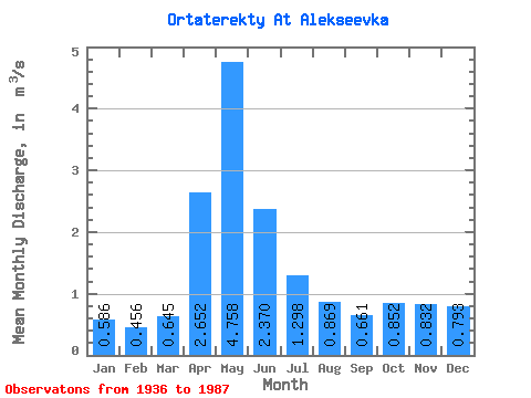
| Statistic | Jan | Feb | Mar | Apr | May | Jun | Jul | Aug | Sep | Oct | Nov | Dec | Annual |
|---|---|---|---|---|---|---|---|---|---|---|---|---|---|
| Mean | 0.59 | 0.46 | 0.65 | 2.65 | 4.76 | 2.37 | 1.30 | 0.87 | 0.66 | 0.85 | 0.83 | 0.79 | 1.28 |
| Standard Deviation | 0.48 | 0.31 | 0.53 | 1.67 | 2.64 | 1.83 | 1.11 | 1.01 | 0.62 | 0.97 | 1.13 | 1.16 | 0.61 |
| Min | 0.14 | 0.17 | 0.12 | 0.23 | 0.70 | 0.33 | 0.20 | 0.14 | 0.12 | 0.22 | 0.26 | 0.22 | 0.47 |
| Max | 1.96 | 1.27 | 2.22 | 7.46 | 9.60 | 7.81 | 5.05 | 4.71 | 2.91 | 4.66 | 4.98 | 4.96 | 3.04 |
| Coefficient of Variation | 0.83 | 0.68 | 0.82 | 0.63 | 0.56 | 0.77 | 0.85 | 1.16 | 0.93 | 1.13 | 1.35 | 1.47 | 0.48 |
 Return to R-Arctic Net Home Page