|
|
|||||||||||||||||
| Point ID: 6956 | Downloads | Plots | Site Data | Code: 11065 |
|
|
|||||||||||||||||
| Download | |
|---|---|
| Site Descriptor Information | Site Time Series Data |
| Link to all available data | |
| View: | Time Series | All |
| Units: | m3/s |
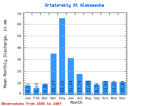
| Statistic | Jan | Feb | Mar | Apr | May | Jun | Jul | Aug | Sep | Oct | Nov | Dec | Annual |
|---|---|---|---|---|---|---|---|---|---|---|---|---|---|
| Mean | 8.00 | 5.67 | 8.81 | 35.07 | 65.02 | 31.34 | 17.73 | 11.87 | 8.74 | 11.64 | 11.00 | 10.83 | 206.06 |
| Standard Deviation | 6.61 | 3.88 | 7.24 | 22.06 | 36.06 | 24.19 | 15.11 | 13.75 | 8.15 | 13.21 | 14.91 | 15.88 | 98.97 |
| Min | 1.91 | 2.12 | 1.64 | 3.04 | 9.56 | 4.36 | 2.73 | 1.91 | 1.59 | 3.01 | 3.44 | 3.01 | 76.35 |
| Max | 26.78 | 15.81 | 30.33 | 98.66 | 131.17 | 103.28 | 69.00 | 64.35 | 38.48 | 63.67 | 65.86 | 67.77 | 489.10 |
| Coefficient of Variation | 0.83 | 0.68 | 0.82 | 0.63 | 0.56 | 0.77 | 0.85 | 1.16 | 0.93 | 1.13 | 1.35 | 1.47 | 0.48 |
 Return to R-Arctic Net Home Page