|
|
|||||||||||||||||
| Point ID: 6954 | Downloads | Plots | Site Data | Other Close Sites | Code: 11061 |
|
|
|||||||||||||||||
| Download | |
|---|---|
| Site Descriptor Information | Site Time Series Data |
| Link to all available data | |
| View: | Time Series | All |
| Units: | mm |
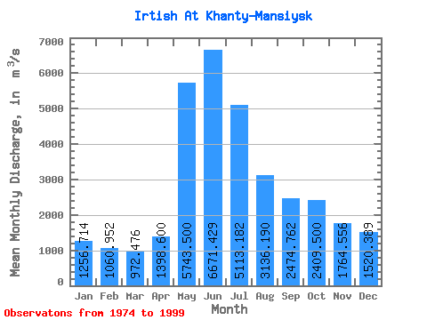
| Statistic | Jan | Feb | Mar | Apr | May | Jun | Jul | Aug | Sep | Oct | Nov | Dec | Annual |
|---|---|---|---|---|---|---|---|---|---|---|---|---|---|
| Mean | 1256.71 | 1060.95 | 972.48 | 1398.60 | 5743.50 | 6671.43 | 5113.18 | 3136.19 | 2474.76 | 2409.50 | 1764.56 | 1520.39 | 2733.30 |
| Standard Deviation | 286.00 | 178.90 | 167.26 | 421.61 | 990.25 | 1216.74 | 1697.21 | 1356.37 | 985.30 | 889.90 | 637.31 | 438.49 | 583.56 |
| Min | 720.00 | 704.00 | 672.00 | 922.00 | 4030.00 | 4290.00 | 2130.00 | 1410.00 | 1280.00 | 1140.00 | 934.00 | 831.00 | 1834.17 |
| Max | 1740.00 | 1370.00 | 1330.00 | 2510.00 | 6780.00 | 8600.00 | 8040.00 | 5990.00 | 4760.00 | 4280.00 | 2720.00 | 2340.00 | 3704.83 |
| Coefficient of Variation | 0.23 | 0.17 | 0.17 | 0.30 | 0.17 | 0.18 | 0.33 | 0.43 | 0.40 | 0.37 | 0.36 | 0.29 | 0.21 |
| Other Close Sites | ||||||
|---|---|---|---|---|---|---|
| PointID | Latitude | Longitude | Drainage Area | Source | Name | |
| 6666 | "Ob At Belogor'e" | 61.07 | -1161373 | SHI | 1152.00 | |
 Return to R-Arctic Net Home Page