|
|
|||||||||||||||||
| Point ID: 6666 | Downloads | Plots | Site Data | Other Close Sites | Code: 10031 |
|
|
|||||||||||||||||
| Download | |
|---|---|
| Site Descriptor Information | Site Time Series Data |
| Link to all available data | |
| View: | Time Series | All |
| Units: | mm |
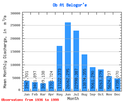
| Statistic | Jan | Feb | Mar | Apr | May | Jun | Jul | Aug | Sep | Oct | Nov | Dec | Annual |
|---|---|---|---|---|---|---|---|---|---|---|---|---|---|
| Mean | 3947.93 | 3401.90 | 3009.14 | 3701.72 | 17122.37 | 26062.29 | 22998.39 | 13874.35 | 9061.29 | 8263.28 | 5624.74 | 4738.07 | 10135.15 |
| Standard Deviation | 663.71 | 539.04 | 491.80 | 1011.35 | 4280.85 | 3463.29 | 6504.99 | 5478.85 | 2228.59 | 2136.99 | 1352.88 | 881.14 | 1620.81 |
| Min | 2790.00 | 2380.00 | 2100.00 | 2100.00 | 1800.00 | 16600.00 | 10000.00 | 6430.00 | 5290.00 | 4760.00 | 3200.00 | 2960.00 | 7205.00 |
| Max | 5600.00 | 4610.00 | 4120.00 | 6560.00 | 24200.00 | 36800.00 | 45600.00 | 29100.00 | 16100.00 | 14300.00 | 8530.00 | 6810.00 | 13908.33 |
| Coefficient of Variation | 0.17 | 0.16 | 0.16 | 0.27 | 0.25 | 0.13 | 0.28 | 0.40 | 0.25 | 0.26 | 0.24 | 0.19 | 0.16 |
| Other Close Sites | ||||||
|---|---|---|---|---|---|---|
| PointID | Latitude | Longitude | Drainage Area | Source | Name | |
| 6954 | "Irtish At Khanty-Mansiysk" | 60.97 | -1140871 | SHI | 20.00 | |
 Return to R-Arctic Net Home Page