|
|
|||||||||||||||||
| Point ID: 6947 | Downloads | Plots | Site Data | Code: 11027 |
|
|
|||||||||||||||||
| Download | |
|---|---|
| Site Descriptor Information | Site Time Series Data |
| Link to all available data | |
| View: | Time Series | All |
| Units: | mm |
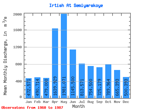
| Statistic | Jan | Feb | Mar | Apr | May | Jun | Jul | Aug | Sep | Oct | Nov | Dec | Annual |
|---|---|---|---|---|---|---|---|---|---|---|---|---|---|
| Mean | 472.57 | 490.71 | 479.00 | 1639.93 | 1981.07 | 1145.50 | 813.57 | 754.50 | 725.18 | 789.96 | 665.39 | 500.39 | 871.48 |
| Standard Deviation | 120.19 | 148.05 | 140.46 | 482.65 | 601.47 | 357.02 | 191.36 | 188.96 | 150.30 | 138.25 | 157.66 | 172.49 | 151.09 |
| Min | 304.00 | 308.00 | 329.00 | 901.00 | 1130.00 | 650.00 | 553.00 | 485.00 | 453.00 | 491.00 | 500.00 | 265.00 | 656.08 |
| Max | 733.00 | 785.00 | 811.00 | 2660.00 | 3300.00 | 1920.00 | 1270.00 | 1470.00 | 1070.00 | 1130.00 | 1130.00 | 1010.00 | 1180.25 |
| Coefficient of Variation | 0.25 | 0.30 | 0.29 | 0.29 | 0.30 | 0.31 | 0.23 | 0.25 | 0.21 | 0.17 | 0.24 | 0.34 | 0.17 |
 Return to R-Arctic Net Home Page