|
|
|||||||||||||||||
| Point ID: 6947 | Downloads | Plots | Site Data | Code: 11027 |
|
|
|||||||||||||||||
| Download | |
|---|---|
| Site Descriptor Information | Site Time Series Data |
| Link to all available data | |
| View: | Time Series | All |
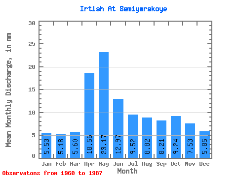
| Units: | m3/s |
| Statistic | Jan | Feb | Mar | Apr | May | Jun | Jul | Aug | Sep | Oct | Nov | Dec | Annual |
|---|---|---|---|---|---|---|---|---|---|---|---|---|---|
| Mean | 3.96 | 3.74 | 4.01 | 13.28 | 16.58 | 9.28 | 6.81 | 6.31 | 5.87 | 6.61 | 5.39 | 4.19 | 85.95 |
| Standard Deviation | 1.01 | 1.13 | 1.18 | 3.91 | 5.03 | 2.89 | 1.60 | 1.58 | 1.22 | 1.16 | 1.28 | 1.44 | 14.90 |
| Min | 2.54 | 2.35 | 2.75 | 7.30 | 9.46 | 5.26 | 4.63 | 4.06 | 3.67 | 4.11 | 4.05 | 2.22 | 64.71 |
| Max | 6.13 | 5.99 | 6.79 | 21.55 | 27.62 | 15.55 | 10.63 | 12.30 | 8.67 | 9.46 | 9.15 | 8.45 | 116.40 |
| Coefficient of Variation | 0.25 | 0.30 | 0.29 | 0.29 | 0.30 | 0.31 | 0.23 | 0.25 | 0.21 | 0.17 | 0.24 | 0.34 | 0.17 |
 Return to R-Arctic Net Home Page