|
|
|||||||||||||||||
| Point ID: 6937 | Downloads | Plots | Site Data | Code: 10625 |
|
|
|||||||||||||||||
| Download | |
|---|---|
| Site Descriptor Information | Site Time Series Data |
| Link to all available data | |
| View: | Time Series | All |
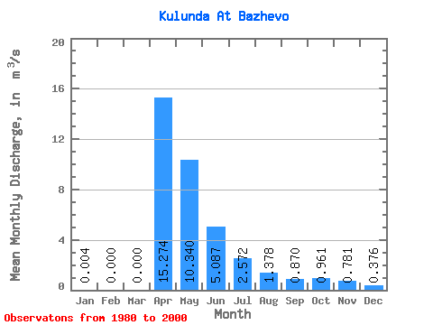
| Units: | mm |
| Statistic | Jan | Feb | Mar | Apr | May | Jun | Jul | Aug | Sep | Oct | Nov | Dec | Annual |
|---|---|---|---|---|---|---|---|---|---|---|---|---|---|
| Mean | 0.00 | 0.00 | 0.00 | 15.27 | 10.34 | 5.09 | 2.57 | 1.38 | 0.87 | 0.96 | 0.78 | 0.38 | 4.81 |
| Standard Deviation | 0.01 | 0.00 | 0.00 | 15.20 | 13.03 | 6.59 | 3.36 | 1.75 | 0.92 | 0.76 | 0.73 | 0.46 | 4.27 |
| Min | 0.00 | 0.00 | 0.00 | 0.91 | 2.08 | 0.65 | 0.00 | 0.00 | 0.00 | 0.00 | 0.00 | 0.00 | 0.52 |
| Max | 0.04 | 0.00 | 0.00 | 50.70 | 51.10 | 25.90 | 11.30 | 5.73 | 3.64 | 2.44 | 2.32 | 1.56 | 10.98 |
| Coefficient of Variation | 3.00 | 0.99 | 1.26 | 1.29 | 1.31 | 1.27 | 1.05 | 0.79 | 0.94 | 1.21 | 0.89 |
 Return to R-Arctic Net Home Page