|
|
|||||||||||||||||
| Point ID: 6937 | Downloads | Plots | Site Data | Code: 10625 |
|
|
|||||||||||||||||
| Download | |
|---|---|
| Site Descriptor Information | Site Time Series Data |
| Link to all available data | |
| View: | Time Series | All |
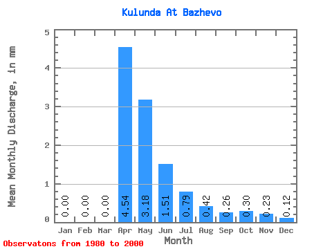
| Units: | m3/s |
| Statistic | Jan | Feb | Mar | Apr | May | Jun | Jul | Aug | Sep | Oct | Nov | Dec | Annual |
|---|---|---|---|---|---|---|---|---|---|---|---|---|---|
| Mean | 0.00 | 0.00 | 0.00 | 4.54 | 3.18 | 1.51 | 0.79 | 0.42 | 0.26 | 0.29 | 0.23 | 0.12 | 17.41 |
| Standard Deviation | 0.00 | 0.00 | 0.00 | 4.52 | 4.00 | 1.96 | 1.03 | 0.54 | 0.27 | 0.23 | 0.22 | 0.14 | 15.45 |
| Min | 0.00 | 0.00 | 0.00 | 0.27 | 0.64 | 0.19 | 0.00 | 0.00 | 0.00 | 0.00 | 0.00 | 0.00 | 1.87 |
| Max | 0.01 | 0.00 | 0.00 | 15.07 | 15.69 | 7.70 | 3.47 | 1.76 | 1.08 | 0.75 | 0.69 | 0.48 | 39.73 |
| Coefficient of Variation | 3.00 | 0.99 | 1.26 | 1.29 | 1.31 | 1.27 | 1.05 | 0.79 | 0.94 | 1.21 | 0.89 |
 Return to R-Arctic Net Home Page