|
|
|||||||||||||||||
| Point ID: 6926 | Downloads | Plots | Site Data | Other Close Sites | Code: 10591 |
|
|
|||||||||||||||||
| Download | |
|---|---|
| Site Descriptor Information | Site Time Series Data |
| Link to all available data | |
| View: | Time Series | All |
| Units: | mm |
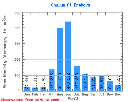
| Statistic | Jan | Feb | Mar | Apr | May | Jun | Jul | Aug | Sep | Oct | Nov | Dec | Annual |
|---|---|---|---|---|---|---|---|---|---|---|---|---|---|
| Mean | 27.64 | 22.31 | 23.70 | 137.35 | 401.35 | 440.22 | 157.28 | 109.96 | 91.35 | 98.57 | 64.19 | 37.53 | 133.12 |
| Standard Deviation | 5.39 | 4.70 | 8.91 | 54.68 | 91.55 | 147.10 | 44.61 | 29.62 | 30.13 | 43.45 | 38.35 | 9.76 | 20.87 |
| Min | 16.80 | 9.60 | 9.59 | 59.60 | 243.00 | 207.00 | 82.40 | 67.30 | 51.20 | 54.20 | 20.90 | 26.50 | 93.43 |
| Max | 35.30 | 28.70 | 47.90 | 262.00 | 592.00 | 765.00 | 239.00 | 161.00 | 143.00 | 213.00 | 189.00 | 59.50 | 170.08 |
| Coefficient of Variation | 0.20 | 0.21 | 0.38 | 0.40 | 0.23 | 0.33 | 0.28 | 0.27 | 0.33 | 0.44 | 0.60 | 0.26 | 0.16 |
| Other Close Sites | ||||||
|---|---|---|---|---|---|---|
| PointID | Latitude | Longitude | Drainage Area | Source | Name | |
| 6790 | "Chulym At Krasny Zavod" | 56.17 | -4530 | SHI | 1180.00 | |
 Return to R-Arctic Net Home Page