|
|
|||||||||||||||||
| Point ID: 6790 | Downloads | Plots | Site Data | Other Close Sites | Code: 10323 |
|
|
|||||||||||||||||
| Download | |
|---|---|
| Site Descriptor Information | Site Time Series Data |
| Link to all available data | |
| View: | Time Series | All |
| Units: | mm |
| Statistic | Jan | Feb | Mar | Apr | May | Jun | Jul | Aug | Sep | Oct | Nov | Dec | Annual |
|---|---|---|---|---|---|---|---|---|---|---|---|---|---|
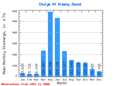
| Mean | 33.64 | 25.71 | 26.00 | 234.89 | 585.94 | 529.11 | 231.03 | 151.65 | 127.31 | 123.06 | 70.48 | 47.41 | 182.51 |
| Standard Deviation | 9.38 | 9.12 | 11.25 | 127.13 | 175.41 | 176.86 | 84.72 | 61.49 | 49.45 | 43.40 | 23.87 | 13.47 | 36.19 |
| Min | 15.00 | 12.20 | 9.50 | 36.10 | 363.00 | 245.00 | 87.30 | 75.50 | 58.90 | 60.30 | 34.60 | 21.50 | 120.60 |
| Max | 59.60 | 54.10 | 68.70 | 689.00 | 1480.00 | 1000.00 | 463.00 | 446.00 | 344.00 | 261.00 | 134.00 | 76.00 | 272.11 |
| Coefficient of Variation | 0.28 | 0.35 | 0.43 | 0.54 | 0.30 | 0.33 | 0.37 | 0.41 | 0.39 | 0.35 | 0.34 | 0.28 | 0.20 |
| Other Close Sites | ||||||
|---|---|---|---|---|---|---|
| PointID | Latitude | Longitude | Drainage Area | Source | Name | |
| 6926 | "Chulym At Ershovo" | 55.98 | -19518 | SHI | 1282.00 | |
 Return to R-Arctic Net Home Page