|
|
|||||||||||||||||
| Point ID: 6916 | Downloads | Plots | Site Data | Code: 10580 |
|
|
|||||||||||||||||
| Download | |
|---|---|
| Site Descriptor Information | Site Time Series Data |
| Link to all available data | |
| View: | Time Series | All |
| Units: | mm |
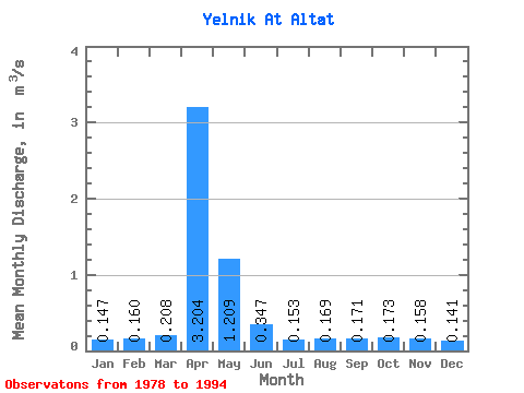
| Statistic | Jan | Feb | Mar | Apr | May | Jun | Jul | Aug | Sep | Oct | Nov | Dec | Annual |
|---|---|---|---|---|---|---|---|---|---|---|---|---|---|
| Mean | 0.15 | 0.16 | 0.21 | 3.20 | 1.21 | 0.35 | 0.15 | 0.17 | 0.17 | 0.17 | 0.16 | 0.14 | 0.53 |
| Standard Deviation | 0.04 | 0.05 | 0.26 | 1.71 | 2.40 | 0.26 | 0.05 | 0.06 | 0.05 | 0.06 | 0.05 | 0.04 | 0.27 |
| Min | 0.08 | 0.04 | 0.06 | 0.96 | 0.13 | 0.07 | 0.07 | 0.04 | 0.05 | 0.07 | 0.08 | 0.07 | 0.25 |
| Max | 0.23 | 0.24 | 1.16 | 7.17 | 10.10 | 0.85 | 0.23 | 0.26 | 0.25 | 0.29 | 0.26 | 0.22 | 1.23 |
| Coefficient of Variation | 0.29 | 0.33 | 1.24 | 0.53 | 1.99 | 0.74 | 0.31 | 0.37 | 0.30 | 0.34 | 0.32 | 0.28 | 0.50 |
 Return to R-Arctic Net Home Page