|
|
|||||||||||||||||
| Point ID: 6916 | Downloads | Plots | Site Data | Code: 10580 |
|
|
|||||||||||||||||
| Download | |
|---|---|
| Site Descriptor Information | Site Time Series Data |
| Link to all available data | |
| View: | Time Series | All |
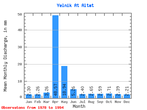
| Units: | m3/s |
| Statistic | Jan | Feb | Mar | Apr | May | Jun | Jul | Aug | Sep | Oct | Nov | Dec | Annual |
|---|---|---|---|---|---|---|---|---|---|---|---|---|---|
| Mean | 2.30 | 2.29 | 3.27 | 48.57 | 18.93 | 5.26 | 2.40 | 2.65 | 2.58 | 2.72 | 2.39 | 2.20 | 98.22 |
| Standard Deviation | 0.68 | 0.75 | 4.05 | 25.91 | 37.62 | 3.89 | 0.74 | 0.97 | 0.79 | 0.91 | 0.76 | 0.61 | 49.50 |
| Min | 1.25 | 0.61 | 0.91 | 14.55 | 2.04 | 1.14 | 1.13 | 0.70 | 0.73 | 1.13 | 1.18 | 1.16 | 45.36 |
| Max | 3.60 | 3.42 | 18.17 | 108.68 | 158.17 | 12.88 | 3.60 | 4.07 | 3.79 | 4.54 | 3.94 | 3.44 | 226.55 |
| Coefficient of Variation | 0.29 | 0.33 | 1.24 | 0.53 | 1.99 | 0.74 | 0.31 | 0.37 | 0.30 | 0.34 | 0.32 | 0.28 | 0.50 |
 Return to R-Arctic Net Home Page