|
|
|||||||||||||||||
| Point ID: 6913 | Downloads | Plots | Site Data | Code: 10576 |
|
|
|||||||||||||||||
| Download | |
|---|---|
| Site Descriptor Information | Site Time Series Data |
| Link to all available data | |
| View: | Time Series | All |
| Units: | mm |
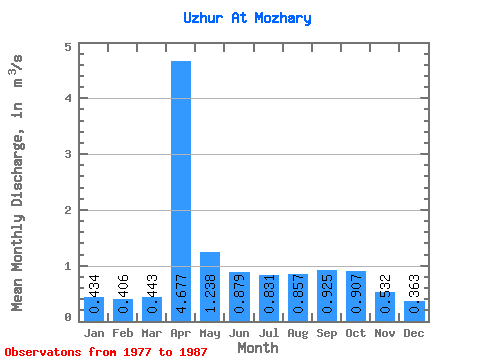
| Statistic | Jan | Feb | Mar | Apr | May | Jun | Jul | Aug | Sep | Oct | Nov | Dec | Annual |
|---|---|---|---|---|---|---|---|---|---|---|---|---|---|
| Mean | 0.43 | 0.41 | 0.44 | 4.68 | 1.24 | 0.88 | 0.83 | 0.86 | 0.93 | 0.91 | 0.53 | 0.36 | 0.99 |
| Standard Deviation | 0.41 | 0.35 | 0.25 | 2.61 | 0.45 | 0.23 | 0.31 | 0.30 | 0.33 | 0.36 | 0.12 | 0.11 | 0.37 |
| Min | 0.21 | 0.20 | 0.18 | 1.09 | 0.74 | 0.62 | 0.33 | 0.60 | 0.62 | 0.57 | 0.34 | 0.23 | 0.58 |
| Max | 1.52 | 1.33 | 0.98 | 9.11 | 2.26 | 1.25 | 1.41 | 1.39 | 1.45 | 1.68 | 0.70 | 0.59 | 1.62 |
| Coefficient of Variation | 0.95 | 0.87 | 0.57 | 0.56 | 0.37 | 0.26 | 0.38 | 0.35 | 0.36 | 0.40 | 0.23 | 0.31 | 0.37 |
 Return to R-Arctic Net Home Page