|
|
|||||||||||||||||
| Point ID: 6913 | Downloads | Plots | Site Data | Code: 10576 |
|
|
|||||||||||||||||
| Download | |
|---|---|
| Site Descriptor Information | Site Time Series Data |
| Link to all available data | |
| View: | Time Series | All |
| Units: | m3/s |
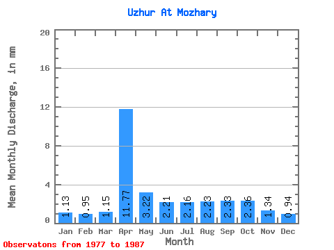
| Statistic | Jan | Feb | Mar | Apr | May | Jun | Jul | Aug | Sep | Oct | Nov | Dec | Annual |
|---|---|---|---|---|---|---|---|---|---|---|---|---|---|
| Mean | 1.13 | 0.96 | 1.15 | 11.77 | 3.22 | 2.21 | 2.16 | 2.23 | 2.33 | 2.36 | 1.34 | 0.94 | 30.26 |
| Standard Deviation | 1.07 | 0.83 | 0.66 | 6.56 | 1.18 | 0.57 | 0.81 | 0.78 | 0.84 | 0.94 | 0.30 | 0.30 | 11.23 |
| Min | 0.55 | 0.47 | 0.47 | 2.74 | 1.92 | 1.56 | 0.86 | 1.56 | 1.56 | 1.48 | 0.86 | 0.60 | 17.82 |
| Max | 3.95 | 3.15 | 2.55 | 22.93 | 5.88 | 3.15 | 3.67 | 3.61 | 3.65 | 4.37 | 1.76 | 1.53 | 49.64 |
| Coefficient of Variation | 0.95 | 0.87 | 0.57 | 0.56 | 0.37 | 0.26 | 0.38 | 0.35 | 0.36 | 0.40 | 0.23 | 0.31 | 0.37 |
 Return to R-Arctic Net Home Page