|
|
|||||||||||||||||
| Point ID: 6910 | Downloads | Plots | Site Data | Code: 10571 |
|
|
|||||||||||||||||
| Download | |
|---|---|
| Site Descriptor Information | Site Time Series Data |
| Link to all available data | |
| View: | Time Series | All |
| Units: | mm |
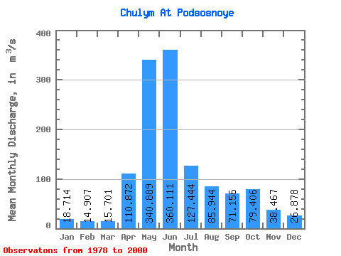
| Statistic | Jan | Feb | Mar | Apr | May | Jun | Jul | Aug | Sep | Oct | Nov | Dec | Annual |
|---|---|---|---|---|---|---|---|---|---|---|---|---|---|
| Mean | 18.71 | 14.91 | 15.70 | 110.87 | 340.89 | 360.11 | 127.44 | 85.94 | 71.16 | 79.41 | 38.47 | 26.88 | 107.54 |
| Standard Deviation | 5.47 | 4.08 | 3.85 | 67.39 | 55.14 | 110.02 | 34.98 | 23.98 | 24.20 | 35.43 | 13.59 | 9.05 | 15.35 |
| Min | 9.67 | 9.02 | 9.31 | 49.60 | 213.00 | 160.00 | 57.70 | 49.00 | 39.40 | 44.90 | 19.20 | 13.60 | 74.03 |
| Max | 30.60 | 22.40 | 25.40 | 350.00 | 420.00 | 534.00 | 189.00 | 134.00 | 123.00 | 174.00 | 64.20 | 52.80 | 129.74 |
| Coefficient of Variation | 0.29 | 0.27 | 0.24 | 0.61 | 0.16 | 0.31 | 0.27 | 0.28 | 0.34 | 0.45 | 0.35 | 0.34 | 0.14 |
 Return to R-Arctic Net Home Page