|
|
|||||||||||||||||
| Point ID: 6910 | Downloads | Plots | Site Data | Code: 10571 |
|
|
|||||||||||||||||
| Download | |
|---|---|
| Site Descriptor Information | Site Time Series Data |
| Link to all available data | |
| View: | Time Series | All |
| Units: | m3/s |
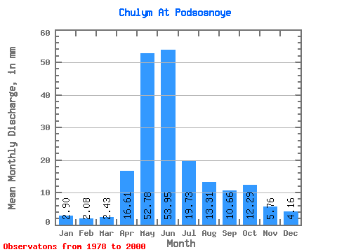
| Statistic | Jan | Feb | Mar | Apr | May | Jun | Jul | Aug | Sep | Oct | Nov | Dec | Annual |
|---|---|---|---|---|---|---|---|---|---|---|---|---|---|
| Mean | 2.90 | 2.10 | 2.43 | 16.61 | 52.77 | 53.95 | 19.73 | 13.30 | 10.66 | 12.29 | 5.76 | 4.16 | 196.19 |
| Standard Deviation | 0.85 | 0.58 | 0.60 | 10.10 | 8.54 | 16.48 | 5.42 | 3.71 | 3.63 | 5.48 | 2.04 | 1.40 | 28.00 |
| Min | 1.50 | 1.27 | 1.44 | 7.43 | 32.97 | 23.97 | 8.93 | 7.58 | 5.90 | 6.95 | 2.88 | 2.10 | 135.04 |
| Max | 4.74 | 3.16 | 3.93 | 52.44 | 65.02 | 80.01 | 29.26 | 20.74 | 18.43 | 26.93 | 9.62 | 8.17 | 236.69 |
| Coefficient of Variation | 0.29 | 0.27 | 0.24 | 0.61 | 0.16 | 0.31 | 0.27 | 0.28 | 0.34 | 0.45 | 0.35 | 0.34 | 0.14 |
 Return to R-Arctic Net Home Page