|
|
|||||||||||||||||
| Point ID: 691 | Downloads | Plots | Site Data | Code: 07CA013 |
|
|
|||||||||||||||||
| Download | |
|---|---|
| Site Descriptor Information | Site Time Series Data |
| Link to all available data | |
| View: | Time Series | All |
| Units: | mm |
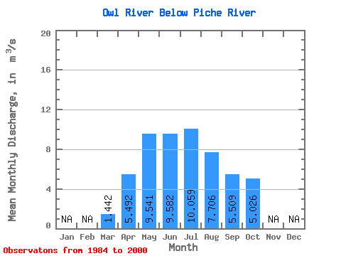
| Statistic | Jan | Feb | Mar | Apr | May | Jun | Jul | Aug | Sep | Oct | Nov | Dec | Annual |
|---|---|---|---|---|---|---|---|---|---|---|---|---|---|
| Mean | 1.44 | 5.49 | 9.54 | 9.58 | 10.06 | 7.71 | 5.51 | 5.03 | |||||
| Standard Deviation | 0.81 | 2.30 | 8.99 | 11.84 | 12.94 | 8.64 | 7.10 | 6.82 | |||||
| Min | 0.37 | 1.88 | 1.78 | 1.77 | 1.09 | 1.07 | 0.95 | 0.88 | |||||
| Max | 3.36 | 9.56 | 33.60 | 52.30 | 57.40 | 31.50 | 25.20 | 24.10 | |||||
| Coefficient of Variation | 0.56 | 0.42 | 0.94 | 1.24 | 1.29 | 1.12 | 1.29 | 1.36 |
 Return to R-Arctic Net Home Page