|
|
|||||||||||||||||
| Point ID: 691 | Downloads | Plots | Site Data | Code: 07CA013 |
|
|
|||||||||||||||||
| Download | |
|---|---|
| Site Descriptor Information | Site Time Series Data |
| Link to all available data | |
| View: | Time Series | All |
| Units: | m3/s |
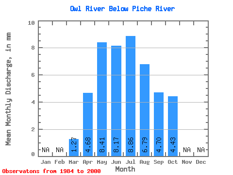
| Statistic | Jan | Feb | Mar | Apr | May | Jun | Jul | Aug | Sep | Oct | Nov | Dec | Annual |
|---|---|---|---|---|---|---|---|---|---|---|---|---|---|
| Mean | 1.25 | 4.62 | 8.30 | 8.06 | 8.75 | 6.70 | 4.64 | 4.37 | |||||
| Standard Deviation | 0.71 | 1.93 | 7.82 | 9.96 | 11.25 | 7.51 | 5.98 | 5.93 | |||||
| Min | 0.32 | 1.58 | 1.55 | 1.49 | 0.95 | 0.93 | 0.80 | 0.76 | |||||
| Max | 2.92 | 8.04 | 29.21 | 44.01 | 49.91 | 27.39 | 21.21 | 20.95 | |||||
| Coefficient of Variation | 0.56 | 0.42 | 0.94 | 1.24 | 1.29 | 1.12 | 1.29 | 1.36 |
 Return to R-Arctic Net Home Page