|
|
|||||||||||||||||
| Point ID: 6903 | Downloads | Plots | Site Data | Code: 10562 |
|
|
|||||||||||||||||
| Download | |
|---|---|
| Site Descriptor Information | Site Time Series Data |
| Link to all available data | |
| View: | Time Series | All |
| Units: | mm |
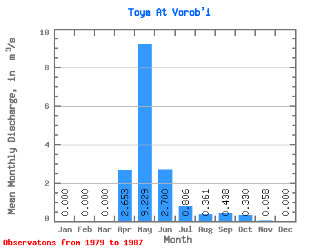
| Statistic | Jan | Feb | Mar | Apr | May | Jun | Jul | Aug | Sep | Oct | Nov | Dec | Annual |
|---|---|---|---|---|---|---|---|---|---|---|---|---|---|
| Mean | 0.00 | 0.00 | 0.00 | 2.65 | 9.23 | 2.70 | 0.81 | 0.36 | 0.44 | 0.33 | 0.06 | 0.00 | 2.28 |
| Standard Deviation | 0.00 | 0.00 | 0.00 | 3.05 | 11.53 | 2.77 | 0.98 | 0.46 | 0.54 | 0.32 | 0.05 | 0.00 | 2.35 |
| Min | 0.00 | 0.00 | 0.00 | 0.81 | 0.40 | 0.09 | 0.03 | 0.06 | 0.08 | 0.07 | 0.02 | 0.00 | 0.62 |
| Max | 0.00 | 0.00 | 0.00 | 10.30 | 34.70 | 7.57 | 2.41 | 1.14 | 1.23 | 0.80 | 0.09 | 0.00 | 3.94 |
| Coefficient of Variation | 1.15 | 1.25 | 1.02 | 1.22 | 1.28 | 1.23 | 0.98 | 0.83 | 1.03 |
 Return to R-Arctic Net Home Page