|
|
|||||||||||||||||
| Point ID: 6903 | Downloads | Plots | Site Data | Code: 10562 |
|
|
|||||||||||||||||
| Download | |
|---|---|
| Site Descriptor Information | Site Time Series Data |
| Link to all available data | |
| View: | Time Series | All |
| Units: | m3/s |
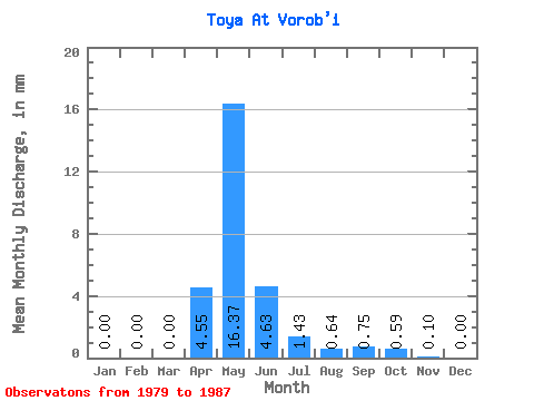
| Statistic | Jan | Feb | Mar | Apr | May | Jun | Jul | Aug | Sep | Oct | Nov | Dec | Annual |
|---|---|---|---|---|---|---|---|---|---|---|---|---|---|
| Mean | 0.00 | 0.00 | 0.00 | 4.55 | 16.37 | 4.63 | 1.43 | 0.64 | 0.75 | 0.58 | 0.10 | 0.00 | 47.65 |
| Standard Deviation | 0.00 | 0.00 | 0.00 | 5.23 | 20.45 | 4.75 | 1.74 | 0.82 | 0.93 | 0.57 | 0.08 | 0.00 | 49.15 |
| Min | 0.00 | 0.00 | 0.00 | 1.39 | 0.71 | 0.15 | 0.05 | 0.11 | 0.14 | 0.12 | 0.04 | 0.00 | 12.90 |
| Max | 0.00 | 0.00 | 0.00 | 17.68 | 61.54 | 12.99 | 4.27 | 2.02 | 2.11 | 1.42 | 0.16 | 0.00 | 82.41 |
| Coefficient of Variation | 1.15 | 1.25 | 1.02 | 1.22 | 1.28 | 1.23 | 0.98 | 0.83 | 1.03 |
 Return to R-Arctic Net Home Page