|
|
|||||||||||||||||
| Point ID: 6899 | Downloads | Plots | Site Data | Code: 10555 |
|
|
|||||||||||||||||
| Download | |
|---|---|
| Site Descriptor Information | Site Time Series Data |
| Link to all available data | |
| View: | Time Series | All |
| Units: | mm |
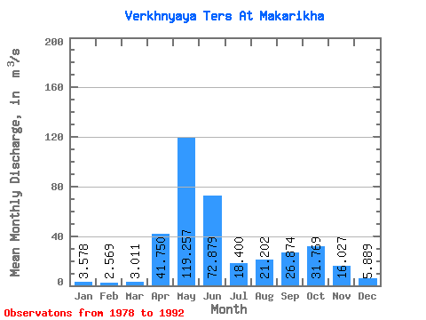
| Statistic | Jan | Feb | Mar | Apr | May | Jun | Jul | Aug | Sep | Oct | Nov | Dec | Annual |
|---|---|---|---|---|---|---|---|---|---|---|---|---|---|
| Mean | 3.58 | 2.57 | 3.01 | 41.75 | 119.26 | 72.88 | 18.40 | 21.20 | 26.87 | 31.77 | 16.03 | 5.89 | 31.00 |
| Standard Deviation | 2.94 | 1.66 | 1.46 | 17.02 | 37.49 | 35.20 | 9.32 | 11.61 | 14.30 | 20.31 | 13.87 | 5.16 | 9.52 |
| Min | 0.08 | 0.08 | 1.74 | 14.50 | 62.40 | 25.90 | 10.30 | 4.59 | 7.16 | 9.90 | 4.44 | 1.05 | 16.63 |
| Max | 9.28 | 6.45 | 6.12 | 72.20 | 194.00 | 120.00 | 45.10 | 41.40 | 49.30 | 80.00 | 53.20 | 18.00 | 48.25 |
| Coefficient of Variation | 0.82 | 0.65 | 0.48 | 0.41 | 0.31 | 0.48 | 0.51 | 0.55 | 0.53 | 0.64 | 0.86 | 0.88 | 0.31 |
 Return to R-Arctic Net Home Page