|
|
|||||||||||||||||
| Point ID: 6899 | Downloads | Plots | Site Data | Code: 10555 |
|
|
|||||||||||||||||
| Download | |
|---|---|
| Site Descriptor Information | Site Time Series Data |
| Link to all available data | |
| View: | Time Series | All |
| Units: | m3/s |
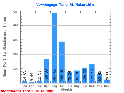
| Statistic | Jan | Feb | Mar | Apr | May | Jun | Jul | Aug | Sep | Oct | Nov | Dec | Annual |
|---|---|---|---|---|---|---|---|---|---|---|---|---|---|
| Mean | 14.63 | 9.57 | 12.31 | 165.22 | 487.59 | 288.40 | 75.23 | 86.69 | 106.35 | 129.89 | 63.42 | 24.08 | 1493.77 |
| Standard Deviation | 12.04 | 6.19 | 5.95 | 67.34 | 153.27 | 139.30 | 38.12 | 47.48 | 56.60 | 83.04 | 54.89 | 21.09 | 458.92 |
| Min | 0.32 | 0.30 | 7.11 | 57.38 | 255.13 | 102.49 | 42.11 | 18.77 | 28.33 | 40.48 | 17.57 | 4.29 | 801.13 |
| Max | 37.94 | 24.03 | 25.02 | 285.71 | 793.18 | 474.87 | 184.39 | 169.27 | 195.09 | 327.08 | 210.53 | 73.59 | 2325.04 |
| Coefficient of Variation | 0.82 | 0.65 | 0.48 | 0.41 | 0.31 | 0.48 | 0.51 | 0.55 | 0.53 | 0.64 | 0.86 | 0.88 | 0.31 |
 Return to R-Arctic Net Home Page