|
|
|||||||||||||||||
| Point ID: 6868 | Downloads | Plots | Site Data | Code: 10494 |
|
|
|||||||||||||||||
| Download | |
|---|---|
| Site Descriptor Information | Site Time Series Data |
| Link to all available data | |
| View: | Time Series | All |
| Units: | mm |
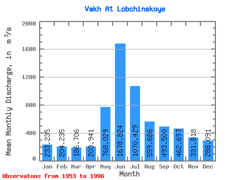
| Statistic | Jan | Feb | Mar | Apr | May | Jun | Jul | Aug | Sep | Oct | Nov | Dec | Annual |
|---|---|---|---|---|---|---|---|---|---|---|---|---|---|
| Mean | 233.24 | 204.24 | 186.71 | 203.94 | 768.03 | 1678.82 | 1070.43 | 559.69 | 493.50 | 462.70 | 331.82 | 288.09 | 535.99 |
| Standard Deviation | 41.08 | 28.32 | 25.72 | 49.70 | 297.50 | 378.84 | 405.01 | 169.45 | 159.65 | 158.15 | 77.05 | 60.53 | 94.06 |
| Min | 164.00 | 154.00 | 141.00 | 139.00 | 257.00 | 1060.00 | 437.00 | 323.00 | 279.00 | 244.00 | 196.00 | 188.00 | 407.00 |
| Max | 315.00 | 273.00 | 252.00 | 388.00 | 1710.00 | 2450.00 | 1820.00 | 894.00 | 949.00 | 822.00 | 464.00 | 394.00 | 703.92 |
| Coefficient of Variation | 0.18 | 0.14 | 0.14 | 0.24 | 0.39 | 0.23 | 0.38 | 0.30 | 0.32 | 0.34 | 0.23 | 0.21 | 0.17 |
 Return to R-Arctic Net Home Page