|
|
| Point ID: 6868 | Downloads | Plots | Site Data | Code: 10494 |
|
| Download | |
|---|---|
| Site Descriptor Information | Site Time Series Data |
| Link to all available data | |
|
|
|
| View: | Statistics | All |
| Units: | mm |
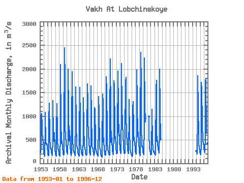
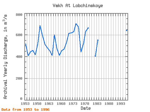
| Year | Jan | Feb | Mar | Apr | May | Jun | Jul | Aug | Sep | Oct | Nov | Dec | Annual | 1953 | 237.00 | 251.00 | 228.00 | 342.00 | 994.00 | 1060.00 | 784.00 | 592.00 | 550.00 | 547.00 | 388.00 | 223.00 | 516.33 | 1954 | 196.00 | 187.00 | 151.00 | 169.00 | 741.00 | 1080.00 | 437.00 | 394.00 | 426.00 | 422.00 | 355.00 | 343.00 | 408.42 | 1955 | 247.00 | 202.00 | 169.00 | 171.00 | 916.00 | 1270.00 | 586.00 | 447.00 | 426.00 | 354.00 | 298.00 | 280.00 | 447.17 | 1956 | 232.00 | 201.00 | 177.00 | 163.00 | 512.00 | 1330.00 | 603.00 | 487.00 | 463.00 | 653.00 | 357.00 | 295.00 | 456.08 | 1957 | 223.00 | 187.00 | 172.00 | 159.00 | 712.00 | 1260.00 | 657.00 | 471.00 | 354.00 | 305.00 | 282.00 | 224.00 | 417.17 | 1958 | 182.00 | 178.00 | 168.00 | 158.00 | 569.00 | 2090.00 | 831.00 | 504.00 | 421.00 | 469.00 | 354.00 | 316.00 | 520.00 | 1959 | 261.00 | 211.00 | 176.00 | 187.00 | 563.00 | 2450.00 | 1740.00 | 761.00 | 572.00 | 599.00 | 407.00 | 317.00 | 687.00 | 1960 | 239.00 | 239.00 | 209.00 | 200.00 | 570.00 | 1990.00 | 1100.00 | 478.00 | 600.00 | 690.00 | 464.00 | 341.00 | 593.33 | 1961 | 256.00 | 206.00 | 172.00 | 234.00 | 863.00 | 1940.00 | 893.00 | 434.00 | 386.00 | 286.00 | 246.00 | 238.00 | 512.83 | 1962 | 231.00 | 186.00 | 172.00 | 222.00 | 910.00 | 1620.00 | 842.00 | 391.00 | 363.00 | 334.00 | 280.00 | 232.00 | 481.92 | 1963 | 200.00 | 187.00 | 172.00 | 156.00 | 589.00 | 1610.00 | 936.00 | 403.00 | 367.00 | 363.00 | 224.00 | 231.00 | 453.17 | 1964 | 192.00 | 182.00 | 162.00 | 175.00 | 571.00 | 1390.00 | 746.00 | 379.00 | 356.00 | 322.00 | 251.00 | 224.00 | 412.50 | 1965 | 190.00 | 182.00 | 182.00 | 189.00 | 599.00 | 1680.00 | 1270.00 | 834.00 | 703.00 | 663.00 | 400.00 | 320.00 | 601.00 | 1966 | 228.00 | 201.00 | 188.00 | 173.00 | 557.00 | 1640.00 | 1020.00 | 433.00 | 369.00 | 314.00 | 311.00 | 259.00 | 474.42 | 1967 | 221.00 | 187.00 | 164.00 | 238.00 | 1180.00 | 1140.00 | 478.00 | 323.00 | 279.00 | 292.00 | 222.00 | 213.00 | 411.42 | 1968 | 187.00 | 162.00 | 154.00 | 183.00 | 796.00 | 1410.00 | 1050.00 | 452.00 | 330.00 | 303.00 | 243.00 | 192.00 | 455.17 | 1969 | 164.00 | 154.00 | 141.00 | 139.00 | 305.00 | 1470.00 | 1280.00 | 453.00 | 528.00 | 490.00 | 270.00 | 246.00 | 470.00 | 1970 | 190.00 | 180.00 | 174.00 | 173.00 | 360.00 | 1830.00 | 1540.00 | 659.00 | 459.00 | 285.00 | 266.00 | 257.00 | 531.08 | 1971 | 214.00 | 190.00 | 184.00 | 176.00 | 933.00 | 2210.00 | 1050.00 | 446.00 | 513.00 | 683.00 | 408.00 | 364.00 | 614.25 | 1972 | 275.00 | 215.00 | 187.00 | 198.00 | 635.00 | 1750.00 | 1640.00 | 765.00 | 526.00 | 564.00 | 340.00 | 321.00 | 618.00 | 1973 | 246.00 | 213.00 | 210.00 | 218.00 | 576.00 | 1950.00 | 1230.00 | 707.00 | 587.00 | 822.00 | 408.00 | 386.00 | 629.42 | 1974 | 296.00 | 236.00 | 212.00 | 248.00 | 1170.00 | 2110.00 | 1140.00 | 894.00 | 851.00 | 579.00 | 394.00 | 317.00 | 703.92 | 1975 | 258.00 | 218.00 | 215.00 | 224.00 | 564.00 | 1720.00 | 1820.00 | 852.00 | 801.00 | 635.00 | 435.00 | 361.00 | 675.25 | 1976 | 285.00 | 217.00 | 215.00 | 225.00 | 1090.00 | 1350.00 | 634.00 | 358.00 | 311.00 | 250.00 | 196.00 | 188.00 | 443.25 | 1977 | 172.00 | 163.00 | 148.00 | 183.00 | 1160.00 | 1310.00 | 750.00 | 485.00 | 554.00 | 542.00 | 378.00 | 368.00 | 517.75 | 1978 | 268.00 | 211.00 | 200.00 | 198.00 | 669.00 | 1980.00 | 1310.00 | 580.00 | 674.00 | 663.00 | 426.00 | 394.00 | 631.08 | 1979 | 315.00 | 233.00 | 190.00 | 172.00 | 845.00 | 2350.00 | 1660.00 | 752.00 | 427.00 | 360.00 | 368.00 | 286.00 | 663.17 | 1980 | 244.00 | 205.00 | 185.00 | 205.00 | 788.00 | 2230.00 | 1230.00 | 872.00 | 949.00 | 1981 | 994.00 | 581.00 | 365.00 | 340.00 | 250.00 | 249.00 | 1982 | 186.00 | 188.00 | 188.00 | 233.00 | 1110.00 | 1150.00 | 447.00 | 336.00 | 303.00 | 244.00 | 252.00 | 247.00 | 407.00 | 1983 | 208.00 | 194.00 | 195.00 | 180.00 | 257.00 | 1590.00 | 1760.00 | 472.00 | 471.00 | 570.00 | 383.00 | 348.00 | 552.33 | 1984 | 310.00 | 273.00 | 240.00 | 216.00 | 683.00 | 2000.00 | 1170.00 | 510.00 | 1994 | 264.00 | 241.00 | 209.00 | 204.00 | 1030.00 | 1850.00 | 1160.00 | 627.00 | 396.00 | 352.00 | 246.00 | 228.00 | 567.25 | 1995 | 210.00 | 196.00 | 187.00 | 388.00 | 1710.00 | 1540.00 | 877.00 | 808.00 | 502.00 | 470.00 | 426.00 | 368.00 | 640.17 | 1996 | 303.00 | 268.00 | 252.00 | 235.00 | 586.00 | 1730.00 | 1800.00 | 649.00 | 597.00 | 504.00 | 422.00 | 331.00 | 639.75 |
|---|
 Return to R-Arctic Net Home Page