|
|
|||||||||||||||||
| Point ID: 6867 | Downloads | Plots | Site Data | Code: 10491 |
|
|
|||||||||||||||||
| Download | |
|---|---|
| Site Descriptor Information | Site Time Series Data |
| Link to all available data | |
| View: | Time Series | All |
| Units: | mm |
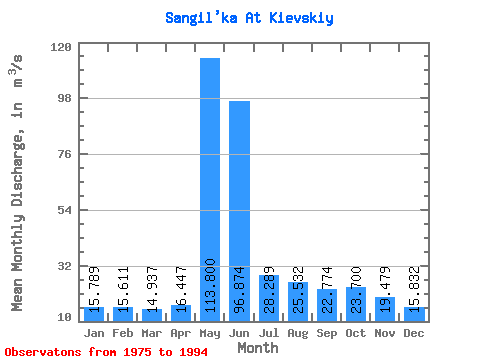
| Statistic | Jan | Feb | Mar | Apr | May | Jun | Jul | Aug | Sep | Oct | Nov | Dec | Annual |
|---|---|---|---|---|---|---|---|---|---|---|---|---|---|
| Mean | 15.79 | 15.61 | 14.94 | 16.45 | 113.80 | 96.87 | 28.29 | 25.53 | 22.77 | 23.70 | 19.48 | 15.83 | 34.09 |
| Standard Deviation | 2.40 | 2.40 | 2.16 | 3.91 | 36.31 | 50.51 | 8.17 | 13.28 | 11.76 | 9.91 | 5.28 | 2.83 | 5.97 |
| Min | 11.80 | 12.20 | 10.20 | 11.70 | 53.80 | 25.30 | 14.00 | 12.60 | 12.90 | 13.00 | 11.90 | 11.40 | 20.54 |
| Max | 20.90 | 20.20 | 18.90 | 25.50 | 167.00 | 239.00 | 41.90 | 68.20 | 62.80 | 53.80 | 29.70 | 21.70 | 44.41 |
| Coefficient of Variation | 0.15 | 0.15 | 0.14 | 0.24 | 0.32 | 0.52 | 0.29 | 0.52 | 0.52 | 0.42 | 0.27 | 0.18 | 0.17 |
 Return to R-Arctic Net Home Page