|
|
|||||||||||||||||
| Point ID: 6867 | Downloads | Plots | Site Data | Code: 10491 |
|
|
|||||||||||||||||
| Download | |
|---|---|
| Site Descriptor Information | Site Time Series Data |
| Link to all available data | |
| View: | Time Series | All |
| Units: | m3/s |
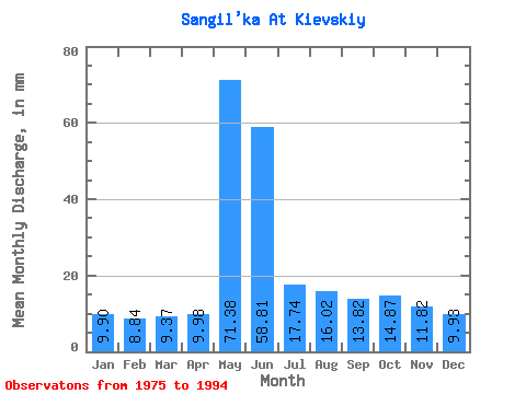
| Statistic | Jan | Feb | Mar | Apr | May | Jun | Jul | Aug | Sep | Oct | Nov | Dec | Annual |
|---|---|---|---|---|---|---|---|---|---|---|---|---|---|
| Mean | 9.90 | 8.92 | 9.37 | 9.98 | 71.37 | 58.80 | 17.74 | 16.01 | 13.82 | 14.86 | 11.82 | 9.93 | 251.95 |
| Standard Deviation | 1.50 | 1.37 | 1.36 | 2.37 | 22.77 | 30.66 | 5.12 | 8.33 | 7.14 | 6.22 | 3.21 | 1.77 | 44.12 |
| Min | 7.40 | 6.97 | 6.40 | 7.10 | 33.74 | 15.36 | 8.78 | 7.90 | 7.83 | 8.15 | 7.22 | 7.15 | 151.83 |
| Max | 13.11 | 11.54 | 11.85 | 15.48 | 104.74 | 145.08 | 26.28 | 42.77 | 38.12 | 33.74 | 18.03 | 13.61 | 328.23 |
| Coefficient of Variation | 0.15 | 0.15 | 0.14 | 0.24 | 0.32 | 0.52 | 0.29 | 0.52 | 0.52 | 0.42 | 0.27 | 0.18 | 0.17 |
 Return to R-Arctic Net Home Page