|
|
|||||||||||||||||
| Point ID: 6841 | Downloads | Plots | Site Data | Code: 10433 |
|
|
|||||||||||||||||
| Download | |
|---|---|
| Site Descriptor Information | Site Time Series Data |
| Link to all available data | |
| View: | Time Series | All |
| Units: | mm |
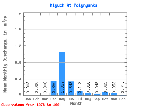
| Statistic | Jan | Feb | Mar | Apr | May | Jun | Jul | Aug | Sep | Oct | Nov | Dec | Annual |
|---|---|---|---|---|---|---|---|---|---|---|---|---|---|
| Mean | 0.00 | 0.00 | 0.00 | 0.35 | 1.06 | 0.34 | 0.11 | 0.06 | 0.05 | 0.09 | 0.05 | 0.02 | 0.19 |
| Standard Deviation | 0.01 | 0.00 | 0.00 | 0.44 | 0.96 | 0.33 | 0.15 | 0.10 | 0.09 | 0.14 | 0.09 | 0.03 | 0.16 |
| Min | 0.00 | 0.00 | 0.00 | 0.01 | 0.09 | 0.01 | 0.00 | 0.00 | 0.00 | 0.00 | 0.00 | 0.00 | 0.03 |
| Max | 0.02 | 0.00 | 0.00 | 1.92 | 3.65 | 1.12 | 0.43 | 0.26 | 0.27 | 0.40 | 0.22 | 0.08 | 0.49 |
| Coefficient of Variation | 2.83 | 1.25 | 0.91 | 0.96 | 1.30 | 1.71 | 1.90 | 1.71 | 1.67 | 1.84 | 0.86 |
 Return to R-Arctic Net Home Page