|
|
|||||||||||||||||
| Point ID: 6841 | Downloads | Plots | Site Data | Code: 10433 |
|
|
|||||||||||||||||
| Download | |
|---|---|
| Site Descriptor Information | Site Time Series Data |
| Link to all available data | |
| View: | Time Series | All |
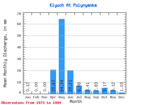
| Units: | m3/s |
| Statistic | Jan | Feb | Mar | Apr | May | Jun | Jul | Aug | Sep | Oct | Nov | Dec | Annual |
|---|---|---|---|---|---|---|---|---|---|---|---|---|---|
| Mean | 0.14 | 0.00 | 0.00 | 20.60 | 64.32 | 20.20 | 6.90 | 3.41 | 2.81 | 5.17 | 3.12 | 1.02 | 133.11 |
| Standard Deviation | 0.39 | 0.00 | 0.00 | 25.72 | 58.32 | 19.50 | 8.99 | 5.81 | 5.35 | 8.82 | 5.22 | 1.89 | 115.08 |
| Min | 0.00 | 0.00 | 0.00 | 0.77 | 5.48 | 0.35 | 0.00 | 0.00 | 0.00 | 0.00 | 0.00 | 0.00 | 22.12 |
| Max | 1.10 | 0.00 | 0.00 | 113.11 | 222.15 | 65.98 | 26.17 | 15.82 | 15.90 | 24.34 | 12.96 | 4.63 | 350.69 |
| Coefficient of Variation | 2.83 | 1.25 | 0.91 | 0.96 | 1.30 | 1.71 | 1.90 | 1.71 | 1.67 | 1.84 | 0.86 |
 Return to R-Arctic Net Home Page