|
|
|||||||||||||||||
| Point ID: 6837 | Downloads | Plots | Site Data | Code: 10426 |
|
|
|||||||||||||||||
| Download | |
|---|---|
| Site Descriptor Information | Site Time Series Data |
| Link to all available data | |
| View: | Time Series | All |
| Units: | mm |
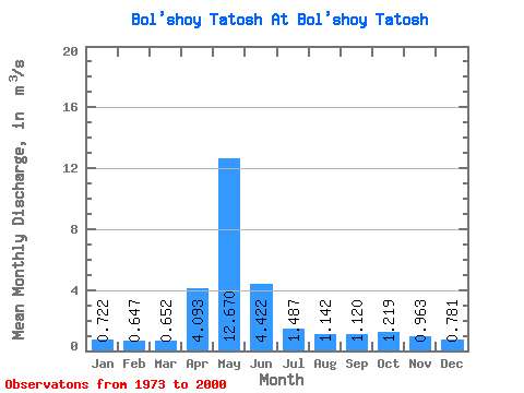
| Statistic | Jan | Feb | Mar | Apr | May | Jun | Jul | Aug | Sep | Oct | Nov | Dec | Annual |
|---|---|---|---|---|---|---|---|---|---|---|---|---|---|
| Mean | 0.72 | 0.65 | 0.65 | 4.09 | 12.67 | 4.42 | 1.49 | 1.14 | 1.12 | 1.22 | 0.96 | 0.78 | 2.49 |
| Standard Deviation | 0.17 | 0.18 | 0.18 | 2.96 | 10.44 | 3.15 | 0.56 | 0.40 | 0.39 | 0.60 | 0.28 | 0.15 | 1.20 |
| Min | 0.43 | 0.29 | 0.25 | 0.57 | 2.23 | 1.22 | 0.66 | 0.61 | 0.70 | 0.65 | 0.52 | 0.46 | 0.96 |
| Max | 1.06 | 1.00 | 0.96 | 9.88 | 32.80 | 13.80 | 2.90 | 2.26 | 2.20 | 3.43 | 1.74 | 1.11 | 5.11 |
| Coefficient of Variation | 0.23 | 0.28 | 0.28 | 0.72 | 0.82 | 0.71 | 0.38 | 0.35 | 0.35 | 0.49 | 0.29 | 0.19 | 0.48 |
 Return to R-Arctic Net Home Page