|
|
|||||||||||||||||
| Point ID: 6837 | Downloads | Plots | Site Data | Code: 10426 |
|
|
|||||||||||||||||
| Download | |
|---|---|
| Site Descriptor Information | Site Time Series Data |
| Link to all available data | |
| View: | Time Series | All |
| Units: | m3/s |
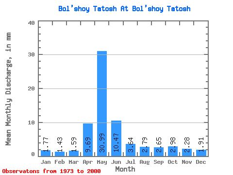
| Statistic | Jan | Feb | Mar | Apr | May | Jun | Jul | Aug | Sep | Oct | Nov | Dec | Annual |
|---|---|---|---|---|---|---|---|---|---|---|---|---|---|
| Mean | 1.77 | 1.44 | 1.59 | 9.69 | 30.98 | 10.47 | 3.64 | 2.79 | 2.65 | 2.98 | 2.28 | 1.91 | 71.86 |
| Standard Deviation | 0.41 | 0.41 | 0.44 | 7.01 | 25.54 | 7.47 | 1.38 | 0.97 | 0.92 | 1.47 | 0.67 | 0.37 | 34.51 |
| Min | 1.05 | 0.65 | 0.61 | 1.35 | 5.45 | 2.89 | 1.61 | 1.49 | 1.66 | 1.59 | 1.23 | 1.12 | 27.79 |
| Max | 2.59 | 2.23 | 2.35 | 23.39 | 80.22 | 32.67 | 7.09 | 5.53 | 5.21 | 8.39 | 4.12 | 2.71 | 147.26 |
| Coefficient of Variation | 0.23 | 0.28 | 0.28 | 0.72 | 0.82 | 0.71 | 0.38 | 0.35 | 0.35 | 0.49 | 0.29 | 0.19 | 0.48 |
 Return to R-Arctic Net Home Page